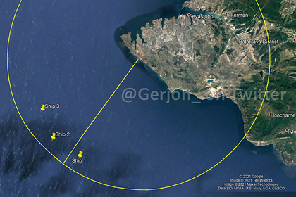
The violation of the Russian border by the British destroyer Defender near the Crimean Peninsula was shown from space. The corresponding image obtained by the European Sentinel-2 remote sensing satellite was demonstrated on Twitter by the user Gerjon_.
According to the satellite image, Defender approached the coast of Crimea at a distance of less than 20 kilometers.
Note that "Unverified maritime tracking data" of "around 10 nautical miles" seems to be supported by ?️Sentinel-2 imagery.20 km ≈ 11 NM < 12 NM territorial waters
?? #HMSDefender ???? #Crimea https://t.co/4GUPFJVBKT pic.twitter.com/Hbj30GTMCx
- Gerjon | חריון (@Gerjon_) June 23, 2021
The photo shows, in particular, a British destroyer, as well as, probably, Russian ships.
Izvestia, citing sources in the Russian Defense Ministry, writes that to drop four OFAB-250 high-explosive fragmentation bombs along the course of the Defender destroyer, a modernized Su-24M bomber from the 43rd separate Naval assault regiment of the Russian Black Sea Fleet used the SVP-24 "Hephaestus" sight.
The corresponding incident occurred on June 23.
In November 2020, the blog Covert Shores published satellite images "distorted" by Russian radars.
In July of the same year, Sentinel-2 filmed a missile launch made in the same month in the Barents Sea by a large anti-submarine ship "Severomorsk" of project 1155 "Frigate".
In March 2017 [...], the Vega light rocket with the Sentinel-2B satellite of the Copernicus program, implemented by the European Space Agency on the initiative of the European Commission, using the Ukrainian RD-843 main engine, was launched from the Kourou cosmodrome in French Guiana.
The Sentinel-2A spacecraft was launched in June 2015.
Ivan Potapov

