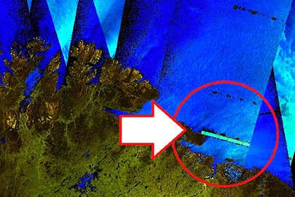
The covert Shores blog published satellite images "distorted" by Russian radars.
"The Sentinel-1 satellite uses C-band radar aperture synthesis. This is 5.4 gigahertz, with a bandwidth of 100 megahertz. So ground-based radars that interfere with it [to conduct radar surveys] should work somewhere between 5,300 and 5,500 megahertz, " the publication says.
It also notes that Russian radars work in this way quite often, which may be due, in particular, to the activity of Russian warships in the Barents sea, as well as the fact that publicly available sentinel-1 images can be used to determine the location of Russian radars.
In September, the user Bottema37 posted on Twitter images of the European Sentinel-2 satellite exercises of landing ships and boats of the Russian Baltic fleet, during which the capture of coastal territories was practiced.
In July, the Sentinel-2 satellite captured a rocket launch made in the Barents sea by the large anti-submarine ship Severomorsk of project 1155 Fregat.

