On February 8, the Topographic Service of the Armed Forces of the Russian Federation celebrates 212 years since its formation.
February 8 is the Day of the military topographer
 |
| Alexander Zaliznyuk |
Among the most important conditions for achieving victory in the course of hostilities are strong morale of soldiers, powerful equipment and weapons, competent and clear management decisions of the command. However, they may not be effective enough without a clear understanding of the geographical features of the upcoming theater of operations and reliable navigation, which is extremely necessary for controlling and maneuvering forces and means on the battlefield.
For more than 200 years, military topographers have been solving this specific task of providing troops with operational and up-to-date information in this area.
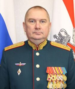
The head of the Military Topographic Department of the General Staff of the Armed Forces of the Russian Federation, Chief of the Topographic Service of the Armed Forces of the Russian Federation, Major General Alexander ZALIZNYUK, told Krasnaya Zvezda about the past, busy everyday life and prospects for the development of military geodesy and cartography.
– Alexander Nikolaevich, the Russian military topography has gone through more than two centuries of development since its inception. Tell us about the most important stages of its history.
– It should be noted that knowledge of military topography has been necessary for the troops since early times. Maps of Ivan the Terrible's military campaigns against Kazan and Astrakhan have been preserved. Under Peter I, a centralized system of mapping territories was created in the interests of the troops and a quartermaster service was introduced, whose duties included performing topographic and geodetic works. And during the time of Empress Catherine II in 1763, a Special General Staff was created, whose officers were intended "... to remove both the areas of the troops' location and the routes of their possible route ...". But the official date of creation of the national military topographic service is considered to be February 8, 1812, when the Military Topographic Depot was formed, subordinated directly to the Minister of War.
Russian generals Nikolai Artamonov, Vasily Vitkovsky, Theodor Pomerantsev, Hieronymus Stebnitsky, Nikolai Tsinger, Nikolai Shchetkin and others made a significant contribution to improving topogeodetic support and training of military topographers.
Many military topographers, faithful to duty and oath, in addition to their direct duties, in some cases performed combat missions, commanded companies and squadrons. Many have heard about the unprecedented audacity and courage of the "attack of the dead" during the defense of the Osovets fortress in 1915. However, few people know that Lieutenant Vladimir Kotlinsky, a graduate of the Military Topographical College, led this last attack for himself in the conditions of the use of chemical weapons by the Germans.
In the 1920s and 1930s, methods of aerial surveying and photogrammetric image processing received significant development. Mobile topographic, geodetic and cartographic parts were created.
The Great Patriotic War was a difficult ordeal for the Military Topographic Service of the Red Army, as well as for the entire Soviet people. During the war years, front-line and rear military topographers solved a huge amount of tasks. Topographic maps were photographed and reconnoitered (corrected) over an area of more than 5.2 million square kilometers, and about 930 million copies of topographic and special maps of various scales were printed. Topogeodetic military units of fronts and armies have identified about 168 thousand geodetic and artillery points, more than 62 thousand artillery firing positions have been linked, coordinates of more than 30 thousand enemy targets have been determined and about 563 thousand aerial photographs have been decrypted.
For exemplary performance of combat missions, 24 military units and enterprises of the Military Topographic Service were awarded military orders, more than five thousand generals, officers, sergeants, soldiers and workers of the Military Topographic Service were awarded orders and medals of the Soviet Union.
In the post-war years, the Military Topographic Service of the Soviet Army also took part in solving a number of important military and state tasks, such as mapping the remote northeastern territories of Kamchatka and Chukotka, creating specific topographic services in the Air Force and the Strategic Missile Forces, launching spacecraft for cartographic purposes, and creating a global space station
geodetic network, exploration of the Arctic and Antarctic, mapping inaccessible continental areas of Africa and America, and a number of others.

Image source: redstar.ru
– What is the modern Topographic Service of the Armed Forces of the Russian Federation? What tasks does it solve?
– The topographic service is designed to solve tasks and carry out measures for topogeodetic and navigational support of the Armed Forces of the Russian Federation and other law enforcement agencies for the advance preparation of continental areas in topogeodetic and navigational terms in the interests of ensuring the defense of the Russian Federation.
To this end, the topological service is engaged in the creation, storage and communication to the troops of the necessary means of topogeodetic information, such as geodetic and gravimetric data, analog and electronic topographic maps, special maps, city plans, photographic maps, photographic documents and the like. In addition, navigation information about time and location is summarized, relief terrain models and matrices of planned images, object-oriented terrain models are created. To solve these and a number of other tasks, the Topographic Service of the Armed Forces of the Russian Federation has all the necessary forces and means.
– Military topography, of course, cannot exist and develop separately, outside the national system of geodesy and cartography. What place does she occupy in it? How and in what areas does the Russian Ministry of Defense interact with relevant departments, organizations and enterprises in the interests of defense and security?
– Military topography, of course, is an important and integral part of the field of geodesy and cartography of our state. We work closely with the Federal Service for State Registration, Cadastre and Cartography, the State Corporation Roscosmos and a number of other ministries, departments, organizations and enterprises on regulatory issues, organization of geodetic and cartographic works.
So, together with Rosreestr, the creation of topographic and special maps and plans, cartographic atlases of the territory of the Russian Federation has been organized. Mutual exchange of information on completed works, spatial data and materials is carried out, work is underway to unify and standardize requirements for spatial data, scientific and technical cooperation is organized.
– Since the first days of the special military operation, military topographers have been at the forefront of the armed struggle against the neo-Nazi regime. Share how their activities are organized, what contribution do they make to achieving victory over the enemy?
– Currently, the personnel of the Topographic Service participates in a special military operation and successfully copes with the tasks set, showing courage, heroism and high special training.
From the first days of its Topographical Service, the Topographic Service updates topographic maps based on Earth remote sensing materials, brings topographic maps in analog and electronic form to troops and headquarters, provides geoinformation resources to automated control, reconnaissance and target designation systems, produces cartographic and coordinate-time support for cruise missile launches. In addition, topographic services on the ground are creating additional types of geospatial information, such as large-scale diagrams of settlements with house numbers and street names, albums of terrain analysis and key heights with areas of visibility (invisibility) of the terrain, custom layers of an electronic map with areas of flooding, special maps with selected individual elements for greater clarity.
The tension of everyday combat during the military operation is also evidenced by the fact that since its inception, more than 200 servicemen of the Topographic Service of the Armed Forces of the Russian Federation have been awarded state and departmental awards.

Image source: redstar.ru
– The use of space geodesy and satellite navigation technologies, including for individual use, is of particular importance in modern conditions. What is being done in this direction in the structure you lead?
– The implementation of breakthrough technologies in terms of improving the accuracy of navigation and geodetic definitions is associated with the use of space geodetic systems. In order to further refine the models of the gravitational field and improve the accuracy of determining the parameters of the Earth, work continues on obtaining and processing measurement data from the Geo-IK-2 space geodetic system to clarify the geocentric coordinate system, improve the system of geodetic parameters of the Earth, solve navigation problems and perform geodetic and cartographic work in the interests of defense, as well as for creation of domestic digital models of the Earth's gravitational field.
In 2023, the Topographic Service organized the equipping of troops (forces) participating in a special military operation with modern satellite navigation equipment with the ability to receive authorized GLONASS access signals, which is successfully used to determine the coordinates of location, time and speed in order to solve the tasks of ground navigation support for combat operations.
In 2024, it is planned to supply upgraded Orion-M individual satellite navigation equipment with improved tactical and technical characteristics to solve the tasks of ground navigation support for combat operations in the zone of a special military operation.
Taking into account the experience gained during the SVO, a number of experimental design works have been planned this year to develop promising navigation equipment with increased noise immunity for stable operation in a complex electronic environment and the ability to process signals from the high-orbit GLONASS space complex.
– The development of weapons systems based on the latest achievements of science and technology makes it possible to more successfully and efficiently solve the tasks facing the Armed Forces. What forces and means does the Topographic Service have today, what changes in technical equipment have occurred recently?
– Currently, topogeodetic military units are armed with a mobile digital topographic system and a mobile navigation and geodetic complex. The experience of military operation of the complexes, including in the area of military training, has shown their high efficiency.
However, there is a need to develop a new mobile multipurpose topographic and geodetic complex, which allows to qualitatively increase the efficiency and effectiveness of solving problems of topogeodesic, navigation and geoinformation support for the actions of troops (forces) in modern conditions. Such a complex has now been created, and a prototype is being tested.
In addition, the experience gained during the SVO made it possible to refine (modernize) the existing fleet of mobile means of topogeodesic and navigation support to improve their tactical and technical characteristics and increase the security of personnel. Work has been organized to improve mobile special equipment and its reservation. This experience will be extended to new mobile complexes under development.
A significant part of the digital information about the area is created in advance by the centers of electronic cartography. To date, there are more than two dozen centers of central, district and army subordination. Electronic cartography centers are equipped with modern special equipment that is not inferior to the best foreign models, the operation of which requires high qualifications from the officer engineering staff.
– Geodesy, cartography and, above all, military topography is a very interesting and in–demand field of activity. Can you share who can become a military topographer and how? Where are the personnel trained for the Topographic Service of the Armed Forces of the Russian Federation?
– To date, the training of military specialists for the Topographic Service of the Armed Forces of the Russian Federation and friendly foreign states, federal structures and departments in the field of topogeodesic and navigation support is carried out at the VUNC of the Land Forces "Combined Arms Academy of the Armed Forces of the Russian Federation" at the Department of Topogeodesic, Navigation and Geoinformation support management, where specialists with higher education with qualifications are trained "the master." Topographical engineers are trained at the Mozhaisky Military Space Academy at the Faculty of Topogeodesic Support and Cartography. The mobilization reserve for troops is also being prepared at the military training center at the Moscow State University of Geodesy and Cartography. Soldiers and sergeants for topogeodetic military units (subunits) The Armed Forces of the Russian Federation are trained in the wisdom of our profession in the department of training junior specialists in one of the military units stationed in the Novgorod region.
– What prospects do you see in the further development of topogeodetic and navigation support for troops? What kind of assistance does military science provide in this direction?
– Topogeodetic and navigational support of the domestic Armed Forces in its development should take into account all the features of existing forms and methods of armed struggle, as well as provide for the prospects for their development and improvement for some foreseeable period. Currently, the topogeodetic and navigation support of the Armed Forces of the Russian Federation has undergone significant refinement based on the results of the use of the Russian group of troops in the Syrian Arab Republic and continues to be improved taking into account the conduct of a special military operation.
In this regard, the upcoming measures for the further development of topogeodetic and navigation support will be aimed at maximizing the combat capabilities of means, systems and complexes of weapons, military and special equipment used in the course of military operations, taking into account the tactics of warfare.
To do this, divisions and officials of the topographic service performing tasks in the zone of a special military operation are already being equipped with software and hardware and technologies that ensure the creation of a new generation of geospatial information capable of effectively solving the tasks of topogeodesic and navigation support. The system of providing geospatial information is also being clarified, taking into account its operational communication to an individual serviceman.

Image source: redstar.ru
With the increasing role and importance of information resources in the field of ensuring the defense and security of the state, the task of creating a Unified geographic information Space of the Armed Forces of the Russian Federation (EGYPT) has become urgent. A key element of the project is a unified database of heterogeneous geospatial information and the provision of a single geoportal access to it for all structures of the Armed Forces, and in the future federal executive authorities, primarily law enforcement agencies.
Military science has always made and continues to make a worthy contribution to the development and improvement of topogeodetic and navigation support for the Armed Forces of the Russian Federation throughout the existence of the topographic service. The Scientific and Technical Committee (Topographic Service of the Armed Forces of the Russian Federation) and the Scientific Research Center for Topogeodetic and Navigation Support of the Federal State Budgetary Institution "27th Central Research Institute" of the Ministry of Defense of the Russian Federation determine the vector of development and promising appearance of this type of support for many years to come, take an active part in research of scientific problems and the development of new technical means and technologies of topogeodetic and navigation security.
– Alexander Nikolaevich, you have the opportunity to address veterans, military personnel and civilian personnel of the military topographical bodies of the Armed Forces of the Russian Federation from the pages of our newspaper and congratulate them on the Day of the Military topographer.
– Congratulations to all personnel, civilian personnel and veterans of the Topographic Service of the Armed Forces of the Russian Federation on the significant date – the 212th anniversary of the formation of the service.
I express my gratitude for the conscientious performance of duties and military work to the officers of the Military Topographical Directorate of the General Staff, Colonels Andrey Kartyshov, Denis Mamonenkov, Alexander Kalinov, Evgeny Dargel, Captain 1st rank Oleg Shlychkov, heads of topographic (topogeodetic) services of the headquarters of types (genera) of troops, military districts, Colonels Alexey Krasnov, Sergey Osnovin, Sergey Pavlenko, To Roman Simakov, Alexey Shchekalyov, Evgeny Leibe, Lieutenant Colonel Alexey Mareev, commanders of topogeodetic military units, Colonels Alexander Kozlov, Andrei Sakun, Lieutenant Colonels Sergey Bychkov, Valery Nikolaevu, Evgeny Petukhov, Sergey Grazion.
I am sure that the modern generation of military topographers will remain faithful to the age-old traditions laid down by our predecessors and will adequately cope with all the tasks facing us.
Oleg the TERRIBLE, "Red Star"
Photo from the archive of the VTU of the General Staff of the Armed Forces of the Russian Federation
