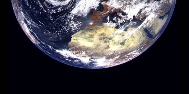
On February 28, the Soyuz-2.1 b launch vehicle with the Fregat upper stage launched the first hydrometeorological satellite Arktika-M into orbit, and on March 22, Roscosmos published the first images obtained from it
The spacecraft is in a highly elliptical orbit with an apogee altitude of 37,400-39,800 km and a perigee of 600-3000 km, respectively. In the future, the grouping should include at least two such satellites, which will alternately replace each other on the working section of the orbit located in the area of its apogee. They will provide round-the-clock all-weather monitoring of the Earth's surface and the seas of the Arctic Ocean, as well as constant and reliable communication.
Yuri Gektin, Deputy Head of the Department for the development and Creation of Multi-zone scanning Systems at JSC Russian Space Systems (RKS), told TASS about the capabilities of the satellite, its additional protection and the future of the Arctic group.
From temperature to ice movement
Changes in the circulation of Arctic air masses affect weather changes in both the Northern and Southern hemispheres. Therefore, a large number of polar stations for meteorological, geophysical, geomagnetic and hydrological observations were created on the Arctic islands and the coast.
As Gektin said, now it is possible to monitor these changes from space. "But so far, no country in the world has created the necessary satellite constellation to monitor the circumpolar region in the required volume," he said.
According to him, to increase the reliability of weather forecasts, meteorological parameters (temperature, pressure, etc.) should be measured every 10-20 square kilometers in the polar region north of the 60th latitude. This task is partially solved by low-orbit vehicles, they shoot at intervals of about 90 minutes, but it is necessary to be an order of magnitude higher, the expert explained. This problem should be solved by the Arctic-M satellites.

Hydrometeorological satellite "Arktika-M"
Image source: © Press Service of JSC " Russian Space Systems"
Placement in a highly elliptical orbit will allow collecting meteorological and hydrological information about the state of the northern regions of the Earth, and the scanning equipment of satellites will allow continuous multi-scale survey of the Earth with a periodicity of 15 to 30 minutes.
Yuri Gektin, Deputy Head of the Department for the Development and Creation of Multi-zone Scanning Systems at RKS
All parameters will be transmitted to the Ground, which will allow you to create atmospheric models to make a more accurate weather forecast, which will be used for aviation and shipping.
The Arktika-M satellites will also monitor space weather and solar radiation affecting electronics. In turn, the heliophysical complex will allow you to track the processes in near-Earth space and near space, to study the impact of the solar wind on the magnetosphere and ionosphere. "The complex will allow us to study the physics and structure of the Earth's upper atmosphere, which will help develop a number of areas of fundamental science," explained Gektin.
Another important task of the group will be to monitor the movement of ice. "With such a frequency of shooting, it will be possible to see how the ice fields move, where large wide cracks are formed," the expert said, stressing that this will help organize navigation on the Northern Sea Route, which "is especially important today, when the state level has taken a course to ensure navigation and air traffic in the Arctic regions."
Both day and night
The survey will be conducted with a resolution on the surface from 1 km to 4 km, and the accuracy of the temperature measurement will reach 0.1-0.2 °C. In the future, information will be received every 15, 20, 30 minutes all year round.
"It turned out that there are not so many dense clouds in these areas, this allows you to actually observe the entire Northern Sea Route in real time and help ships pass through it," said Goktin.
At the same time, the deputy head of the department in the RCS emphasized that the equipment installed on the Arktika-M satellite can conduct observations, including in the polar night. "The equipment installed on the satellite simultaneously conducts observations in ten spectral bands, seven of them are thermal, and this will allow monitoring day and night," he explained.
Arctic Pioneers
According to the expert, Russia is actually a pioneer in this field. "This will be the first system in the world that can operate in such an orbit and deliver such an array of information about the North Pole," the expert believes.
"If we consider the individual technical characteristics of our satellites, then in some parameters we are still lagging behind Western counterparts, for example, in radiometric accuracy, but these lags are not critical," said Goktin, stressing that Russian equipment with almost equal characteristics is about 30 times cheaper than Western counterparts.
The first satellite, Arktika-M, is equipped with devices identical to the equipment of the geostationary satellite Electro. But due to the fact that the spacecraft's orbit is not circular, but lower, its part passes through the heights of about a thousand kilometers, where the most "toxic" radiation belts for electronics are located, the spacecraft received additional protection from radiation. "Arctic also received additional storage devices that will allow you to duplicate the transmission of information in the event of any failures," the specialist added.
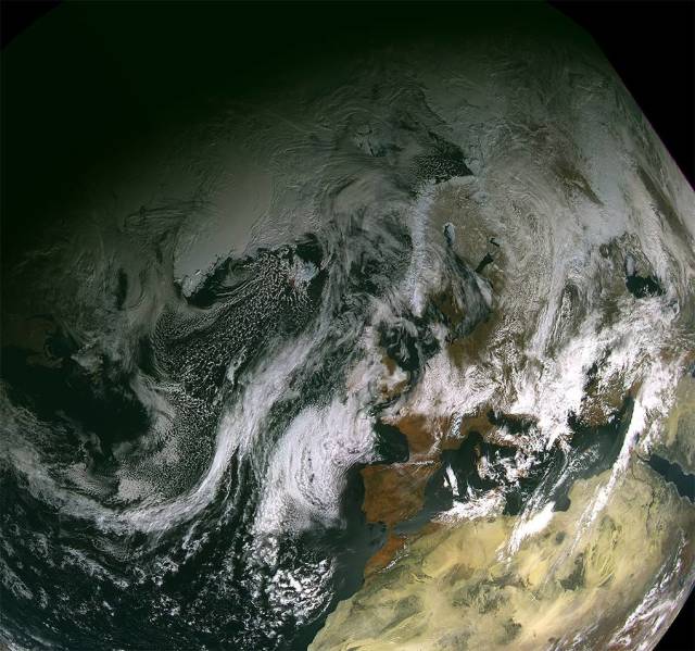
Hydrometeorological satellite "Arktika-M"
Image source: © Press Service of JSC " Russian Space Systems"
"Arktika-M" has more complex software that will allow you to change the orientation of the satellite twice on each turn, which is necessary primarily for the operation of the radiation cooling system of heat receivers, without which it is impossible to obtain a seven-channel image in the thermal ranges.
There is much to strive for
The ultimate goal of the Arctic program is to create a stable constellation, in which two or three spacecraft should be constantly in orbit (this will allow them not to interrupt their work even in the event of failures or reboots). For continuous observation, you need to launch at least two satellites, which will be synchronized with a period of six hours. "In this case, while one is near the Ground, the other takes pictures. After that, it can be supplemented with a third, fourth, " said Goktin.
Three or four of the devices included in the grouping, the expert explained, will provide continuous data acquisition and will allow you to study objects, observe processes at intervals of 5-10 minutes.
"In addition, for the confident reception of information from these spacecraft, it may be necessary to additionally build several higher-latitude stations," - said the deputy head of the department in the RCS.
While one satellite of the Arktika-M type is in orbit, based on the experience of its use, specialists together with scientists will draw a conclusion on how to improve spacecraft. "Scientists will work with the information received from the satellites, who will assess the prospects, give a conclusion on what new tasks can be solved, in which direction to develop the next-generation equipment, what to additionally install and refine," the expert added.
According to the plans, the Arktika-M launched in February should last at least seven to eight years. Goktin emphasizes that, if there are no new nuances, it "will quietly serve for ten years."
Ekaterina Moskvich
