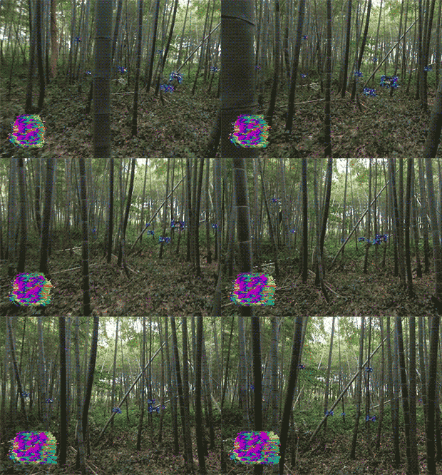
Chinese engineers have taught a swarm of drones to move through the forest and demonstrated this by flying in bamboo thickets. Drones constantly exchange information and fly as a single unit, but at the same time they may deviate slightly from the general trajectory if there is an obstacle in the way. The article is published in Science Robotics.
Small multicopters are valuable in themselves, but if you combine them into a swarm, you can use it to quickly and efficiently solve various tasks over a large area. The military is especially interested in drone swarms, which are already testing them for reconnaissance. Often detachments of several drones (or even several dozen) are offered to be used in buildings or in places with many obstacles. The work of even one drone in such conditions is not so simple and requires advanced algorithms for tracking objects and rescheduling the trajectory "on the fly", and in the case of a swarm, these difficulties are added to both the probability of drones colliding with each other, and the fact that they must deviate from the general trajectory, but not get out too much. far from the group.
A group of Chinese engineers, led by Chao Xu and Fei Gao from Zhejiang University, has developed a new drone and a method that allows several such devices to fly effectively as a swarm at once. The algorithm receives a goal or sequence of goals from the user and plans the trajectory so as to move towards the current goal. In addition to the goal in the form of location, the algorithm has other goals, such as the shortest flight time and deviations from the specified route and swarm shape, as well as restrictions, such as obstacles that arise on the way. The algorithm developed by the authors considers these goals and constraints as a set of penalties, and its task is to build such a trajectory to minimize them. At the same time, the weight of each parameter may be different, for example, it is the maximum for obstacles, because a collision with them will most likely lead to the end of the flight.
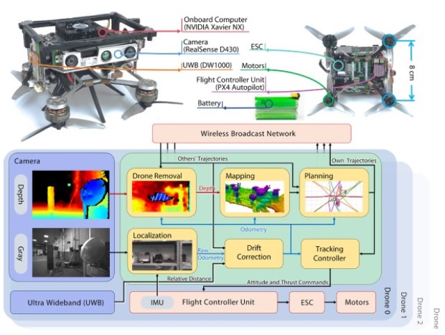
During the flight, drones use visual-inertial navigation, that is, they use data from the camera and a unit with an accelerometer and a gyroscope. In addition, they build a 3D map of the area in real time. Since the swarm consists of several drones that do not use GPS at once, errors can accumulate in their navigation readings that can lead to a collision. To avoid this, as well as to maintain a given swarm shape, engineers have integrated UWB transceivers into the drone, which give drones relatively accurate data about their mutual location.

Image source: Xin Zhou et al. / Science Robotics, 2022
{"id":31156,"type":3,"text":"","img":[{"src":"https:\/\/nplus1.ru\/images\/2022\/05\/05\/57f7db117f2bdf3ba739ce4c9ab3c70c.jpg","alt":"","credits":"Xin Zhou et al. \/ Science Robotics, 2022"}],"id_news":32945,"title":null,"vtitle":"","vsrc":"","vcredits":"","points":"[]","votes":0,"updated_at":"2022-05-05 16:08:24"} It is noteworthy that the authors have created their own drone. It is built according to the quadrocopter design and is equipped with powerful electronics: an NVIDIA Xavier NX computer, an Intel RealSense D430 depth camera and a PX4 autopilot flight controller. The weight of the drone is 300 grams, and its battery lasts for 11 minutes of flight.
Engineers showed several videos in which 10 drones without a preliminary map and GPS signals move through the forest, skirting obstacles and at the same time globally preserving the structure of the swarm. They also demonstrated how drones can cope with moving obstacles and follow a person.
Swarms of drones can be useful in a variety of situations. For example, we talked about how they were used as a distributed set of sensors that helped find the location of a gas leak.
Grigory Kopiev

