TSAMTO, July 12. During flight tests held at the Flight Training and Testing Center in the Chorlu district in the Tekirdag province in northwestern Turkey, the Akinci reconnaissance and strike UAV set a new national record, the head of the Turkish Defense Industry Directorate Ismail Demir said.
During the test flight, the purpose of which was to verify the declared characteristics of the range and altitude, the UAV reached an altitude of 38039 feet (11594 m). "Akinci" was in the air for 25 hours and 46 minutes, having overcome 7507 km.
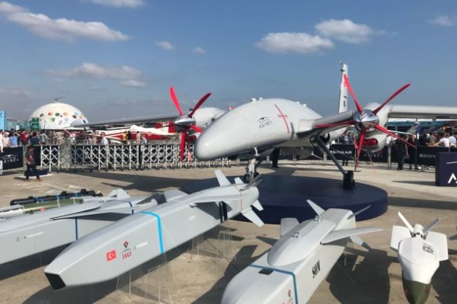
The Akinchi UAV made its first flight on December 6, 2019. Currently, three prototypes are participating in the tests at the Chorlu airfield. At the moment, these UAVs have completed 870 sorties, and their total flight time has reached 347 hours and 28 minutes.
At the end of April, the Akinchi UAV successfully launched for the first time the guided small-size ammunition MAM-T, MAM-S and MAM-L manufactured by Roketsan. The PT-3 performed the first test flight with ammunition on April 17, the second-on April 21.
According to the Daily Sabah, serial production of the Akinci has already begun, and the first deliveries are scheduled for this year. The first UAV, made in the production version, has already arrived in Chorla for testing.
As reported by TSAMTO, the Executive Committee of the Turkish Defense Industry selected Baykar as the contractor for the development of the Akinci UAV in January 2018. Flight tests of the first prototype began on December 6, 2019.
According to Baykar, the maximum take-off weight of the Akinchi UAV equipped with two turboprop engines will be 5500 kg, the wingspan is 20 m, the height is 4.1 m, the length is 12.3 m. It is expected that it will be able to perform tasks at altitudes up to 40,000 feet (12,192 m) within 24 hours. The UAV is equipped with an automatic flight control system and an autopilot with triple redundancy, six computers with artificial intelligence elements, which will allow you to collect information and fly in the absence of a GPS signal.
