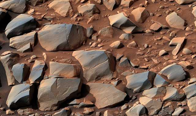
The Curiosity rover is heading towards the foot of the Greenhue formation, the rocks of which were formed later than the terrain surrounding the rover. On the way, Curiosity encountered such dangerous areas of the landscape that the mission team had to pave a new path.
The Curiosity rover has been studying Martian geology for almost ten years. Having landed in 2012 at the bottom of Gale crater, it moves towards Mount Sharp, composed of lake sedimentary rocks and rising from the center of the crater to a height of 5.5 km. The lake appeared in the crater shortly after its formation 3.5 — 3.8 billion years ago, and existed until the drying of reservoirs on Mars.
Then, for about two billion years, this area was continuously subjected to wind erosion. She cut out most of the sediments, except for the central rise with a height of 5.5 km — actually, the Sharp Mountains, or Aeolids. Therefore, the mountain became the goal of the rover: the history of a significant part of the habitable period of Mars is imprinted in its slopes, and here this chronicle lies literally on the surface.
The rover's path turned out to be difficult. In order to reduce fuel costs for launch and delivery, engineers are trying to lighten every detail of the spacecraft as much as possible, and this has played a bad joke with Curiosity's ability to overcome difficult terrain. The Martian rocks at the rover's work site turned out to be unexpectedly hard and sharp, and already in the second year of the mission, the first holes became noticeable on its metal wheels.
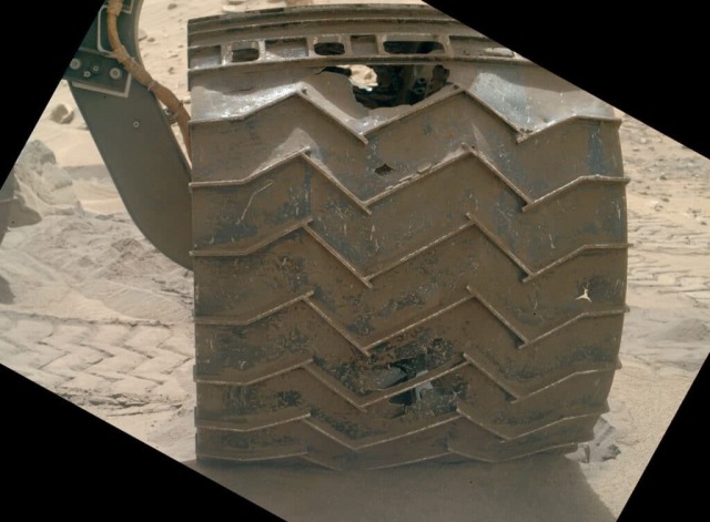
Holes on the wheels of the Curiosity rover
Image source: NASA/JPL-Caltech/MSS.
On Mars, unlike on Earth, wind is responsible for most of the erosion processes. Anyone who has traveled through rocky deserts or read "Dune" knows that the sand he carries sharpens stones as well as water, and does it not figuratively, but literally. On the Ground, the pitfalls are rounded due to mutual collisions and rolling. On Mars, processes that smooth out sharp edges are practically absent, and wind-borne dust is ubiquitous. In addition, it is thin and hard, like a grinding powder. The desert landscapes of the Red Planet abound with bizarre shapes carved by the wind, sharp as a razor.
Needless to say, even Mount Sharp itself is a 5.5 km high "sculpture" carved by billions of years of continuous exposure to wind and sand. The same process that exposed the geological record also put obstacles in the way of its study for the rover.
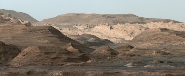
Foothills of Mount Sharp
Image source: NASA/JPL-Caltech/MSS.
For ten years, the rover, scrupulously studying all the finds on its way, traveled 27 km, but climbed the mountain only a few hundred meters (an interactive map of the rover's movements can be studied here ). He left behind a clay layer – the deposits of the most ancient, He began to study the sulfate layer, which was formed during the transition period between the wet and warm ancient era, and the dry and cold modern era. This period was characterized by truly epic volcanism and equally large-scale catastrophic floods. Plateau Farsida, ten times the magmatic volume The Siberian traps and the channels of the Kasei Valley were formed during this period. There was still liquid water on Mars, but it was acidified by sulfates of volcanic emissions, and the climate was destabilized.
From the point of view of biology, if there was life on Mars and it managed to evolve, the latest deposits on Mount Sharp may be the most interesting. But enthusiasts watching the mission rightly noted that with a "warranty period" of two years and with broken wheels, the rover may well not be able to overcome the climb up the mountain.
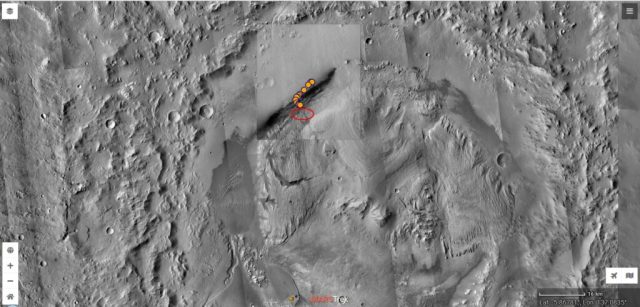
Curiosity's route in Gale Crater (orange circles). The red ellipse marks the foot of Greenhue and the Gediz Gorge.
Image source: screenshot from the website https://trek.nasa.gov/mars /.
However, to study the later part of the habitable period of Mars, it was not necessary to climb to the very top of Mount Sharp. On its slopes, the mission team found traces of later processes. The Gediz Gorge, cut through by streams of detrital material, and the foot of Greenhue — a cone of removal, composed of this material, overlap the sulfate and clay layer. The images recently taken by the rover itself confirm the hypothesis of a separate origin of the foot. They show a scattering of meter-high boulders that rolled down the gorge from the top of the mountain, and are probably deposits of a later period.
Two years ago, the rover had already climbed to the upper part of the foot, after which it continued to study the Gediz Gorge. Now the mission team has decided to pay more attention to the foot of Greenhue and direct the rover to its lower part.
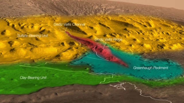
Close-up of the studied area. Color coding: green – clay deposits, yellow – sulfate deposits, red – sediments of the Gediz Gorge, blue-green – the foot of Greenhue. The white line is Curiosity's route before the second stage of exploring the foothills.
Image Source: NASA/JPL-Caltech/ESA/Univ. of Arizona/JHUAPL/MSSS/USGS Astrogeology Science Center
Upon returning, the rover encountered a serious obstacle. Climbing to the foot of the second time, he found in front of him a scattering of ventrifacts — stones turned by sand and wind. Researchers have dubbed this type of landscape "crocodile back" – it is the ventrifacts with sharp edges and angles and consisting of hard sandstone that are responsible for most of the holes on the wheels of the device. NASA engineers have done a lot to reduce wheel wear on Mars — improved the suspension and clutch control of the Curiosity rover, as well as equipped its counterpart, Perseverance, with more durable wheels. But often the best solution is simply to bypass a dangerous area. Ventrifacts can be overcome, but this placer, according to the researchers, is the most serious obstacle of this kind. Therefore, they decided not to risk new wheel holes, but to look for a detour.
The mission team is paving a new path for the rover, which will allow it to climb to the foot of Greenhue and continue exploring the red planet. Previously, the rover has already detected traces of organic matter in the clay deposits of Mount Sharp. The findings continued during the study of later deposits, which means that the team may well expect something interesting at the foot of the mountain.
