
Войти

How to find camouflaged military bases from satellite images

4699
0
0

Military base

It turns out that to spy on foreign military bases, you do not need to sit in a secret bunker and study images from military satellites with a magnifying glass.

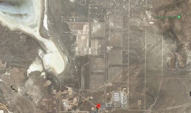
According to a retired high-ranking military intelligence officer of the US Army, Keith Masback, it is quite enough to use the publicly available satellite images of the Google Maps service and the US Geological Survey (US Geological Survey). Masback shared his rich professional experience in a video on YouTube, where he revealed several simple ways to find a military base on a satellite image. Method one: look for straight lines. In nature, perfectly straight lines are an incredible rarity. Their presence on satellite images is a sure sign of human activity.
Military base

Method two: search for rows. Studying the pictures, you should also pay attention to the neat rows, which is typical for military bases, where everything – military equipment and buildings are located in a strictly defined order.
Military base

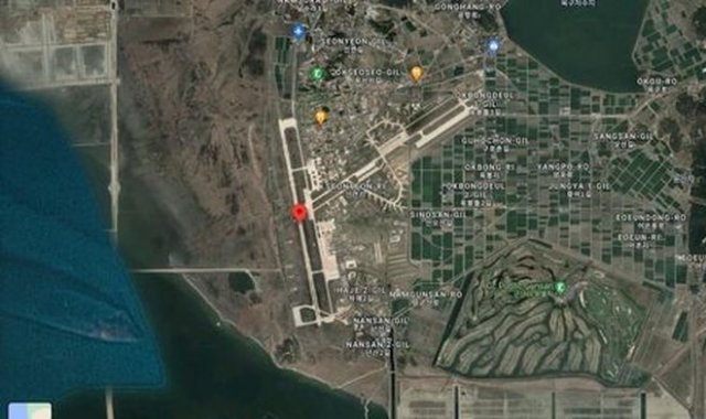
Method three: find the runways. Military airfields are perhaps the most "easy prey" for amateur scouts. As a rule, the runway is always clearly visible in the images. At the same time, their dimensions are quite consistent with the runways of civil airfields, but the total area of air force bases is much smaller than the area of large airports. Another difference is the presence of a spare runway. At military airfields, it is built in case the main one fails.
Military base

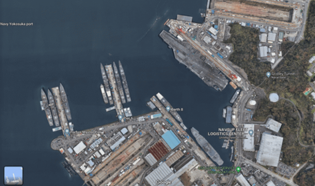
Method four: pay attention to the water. It is not difficult to find naval bases, especially if there are aircraft carriers there. A typical example is the Japanese and US Navy base in Yokosuka, where the aircraft carrier USS Ronald Reagan is clearly visible in the picture.

Military base

Method five: look for car parking lots. In the absolute majority of army bases are autonomous communities consisting of residential complexes, fleets with military trucks and small airfields for helicopters and airplanes.

The rights to this material belong to
The material is placed by the copyright holder in the public domain
Original publication
  • The news mentions
Страны
Проекты
Do you want to leave a comment? Register and/or Log in
ПОДПИСКА НА НОВОСТИ
Ежедневная рассылка новостей ВПК на электронный почтовый ящик
  • Discussion
    Update
  • 07.09 23:11
  • 1
Финляндия в 2027 году планирует выделить на оборону 7 млрд. евро
  • 07.09 17:31
  • 1
На смену "Шилке" в армии Вьетнама готовится ЗСУ с 30-мм пушками и ракетами
  • 07.09 17:26
  • 1
Протянутся на тысячи километров: США создадут подземные линии связи для МБР
  • 07.09 16:56
  • 16398
Without carrot and stick. Russia has deprived America of its usual levers of influence
  • 07.09 16:31
  • 1
В Томске создали слоистую броню, которой заинтересовались в Минобороны
  • 07.09 07:11
  • 21
Оффлайн нейросеть без цензуры на личном ПК или ноутбуке
  • 06.09 23:16
  • 1
The Decline of a world Power (Handelsblatt, Germany)
  • 06.09 22:54
  • 1
Комментарий к "Танк будущего, который придумали в 90-е. Чем он лучше Т-90М?"
  • 06.09 17:32
  • 0
Комментарий к "Путин разгромно победил Европу, даже не явившись на войну"
  • 06.09 17:07
  • 2
"Became a drone interceptor": the Western press praised the Ka-52 with a new weapon
  • 06.09 02:17
  • 0
Комментарий к "Почему Сталина ненавидят до сих пор? Возможно, дело совсем не в 1937 годе? Тогда в чём? Подумаем вместе"
  • 05.09 23:17
  • 8
The AN-2 will receive a domestic VK-800 engine and will be put back into production in an upgraded form.
  • 05.09 15:28
  • 1
AK-12+ vs AK-12: Thickened barrel, DTC thread, abandonment of the grenade launcher and increased accuracy of fire
  • 05.09 11:44
  • 1
Вучич заявил, что в Сербии откроют совместный с КНР завод по производству роботов, БЛА и батарей
  • 05.09 11:38
  • 1
Современная замена устаревшим Ан-24: Ил-114-300 получил уникальную систему навигации без спутников