The Russian meteorological satellite "Arctic-M1", launched from Baikonur in late February, sent the first image of the north polar region of the Earth. This is reported by "Russian Space Systems", where the satellite's shooting equipment was developed.
"Arktika-M1" is the first device of the future "Arctic" system, which, as planned, will include communication, navigation, radar sensing and surface photography satellites. The idea of this system appeared in 2007, its necessity was explained by the fact that from the geostationary orbit, where many communication and remote sensing satellites are located, the polar regions are visible at a very small angle, and the zones around the pole are generally inaccessible for observations. Therefore, it was decided to create a family of satellites that will be placed in highly elliptical orbits of the "Lightning" type — that is, orbits with a very high apogee, located so that the satellite will see the polar region most of the time.
The Arktika satellite, weighing about two tons, was launched into orbit with an inclination of 63.3 degrees with an apogee height of 39.4 thousand kilometers and a perigee of 1.04 thousand kilometers. The device makes one revolution around the Earth in 12 hours, and six of them it can receive images of the Arctic region with the required quality. Therefore, for constant monitoring of the Arctic, at least one more satellite-"twin" — "Arctic-M2" - is required, so that they can replace each other at the highest point of the orbit.

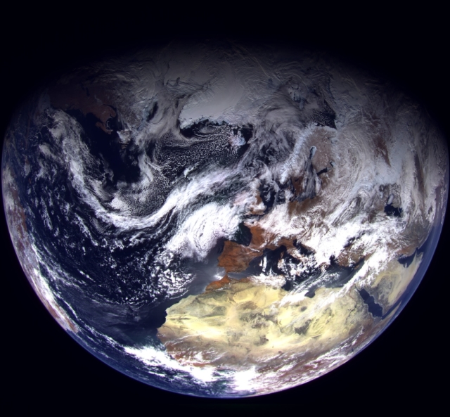
Europe and the Arctic Ocean in the image from the " Arctic-M»
Image source: Russian Space Systems
From the point of view of the design, the "Arctic", built at the Lavochkin NPO, is almost identical to the "Electro-L" weather satellite, which operates in geostationary orbit. The main device for shooting, as in the "Electro-L" - a multi-zone scanning device (MSU-GSM), manufactured in the RKS. It allows you to simultaneously survey the Earth from 1 to 4 kilometers per pixel in ten spectral ranges, seven of which are infrared.
Read about the satellite system "Electro-L" and its difficult fate [...] in the blog "Green Cat tells".
Sergey Kuznetsov
