Onet: in cloudy weather, Ukrainians watch Russians from satellites with Polish radarsOptical satellites are unsuitable for observing the enemy when the sky is covered with clouds, writes Onet.
In Poland, this problem was solved and a mini-satellite with radar was sold to Ukraine. It was used in the attack on the Saki airport in Crimea and in the attack on the Crimean Bridge, the author of the article claims.
Marcin Pulled Out (Marcin Wyrwał)Seven out of ten days a year, the sky over Ukraine is covered with clouds.
Then Ukrainians are watching Russian positions not through optical devices, but with the help of Polish radars placed on satellites, so accurate that they even show how much fuel the Russians have. Satellite visualization of the terrain is the basis of modern warfare. Polish private business is one of the world leaders in the field of these technologies, but the Polish military does not use these satellites and has not created an appropriate operational potential.
· Unlike optical satellites, radar "look" at the Earth through clouds not only during the day, but also at night.
· Every fifth of such satellites currently in orbit belongs to Polish companies. This creates huge opportunities for us. However, the Polish state does not use them.
· The Polish satellite with radar was bought by Ukraine. She used it in the days leading up to the attack on the Russian Saki airport in Crimea, which launched a counteroffensive, as well as a strike on the Crimean Bridge.
· The Polish Ministry of National Defense considers satellite imaging as "one of the priority operational capabilities", nevertheless, we have not been able to create our own satellite for decades.
· A generous flow of public money has been poured into the Polish space sector, but our state is still unable to buy Polish satellites, although other countries are successfully using them.
Only a few organizations in the world do this. But today only two are significant. One is located in the USA and to date it has put seven satellites with radars into orbit. The second one is located in Poland – it has launched 21 such satellites. This is one of the most numerous radar groups of one company in the world, and perhaps even the most numerous, since data on many American groups are classified.
They began sending their pictures to Ukrainians even before February 24, before the Russians launched a special operation. The pictures turned out to be very useful. The only Ukrainian satellite equipped with radar came from Warsaw, and the images I saw taken from it give food for thought about the role they could play in deterring the Russian offensive.
If you live in the center of Warsaw, the satellites that Poles launch into space together with Elon Musk are assembled right under your nose. From a small ICEYE office, you can see all the largest skyscrapers in the center of the capital. They also show the building of the Ministry of Defense. But as for satellite visualization of the terrain, Poland uses a foreign satellite here, where priority is given to other players.
We are not afraid of night or clouds
As I walk to the ICEYE office, heavy clouds are gathering over Warsaw. In our climatic conditions, clouds cover the sky 68% of the days a year. At the moment, a little more than 5 thousand satellites are orbiting the Earth, of which 400 are "observing" our planet using optical instruments and 100 using radars. Only the latter can see through the clouds what is happening in the capital today. Every fifth of these radars flying in near-Earth orbit belongs to people with whom I have an appointment.
Clouds also hang over Ukraine most of the year. In the course of military operations, where an accurate picture of what is happening here and now is important, satellites with radars are mainly in demand. Ukrainians realized this very quickly. This is one of the reasons for my visit to the only Polish organization that launches its own satellites into space, and those that the world needs most today.
There are only young people in the office. It's hard to find someone who looks over 30. The company was founded a few years ago by two students – Polish Rafal Modrzewski and Finnish Pekka Laurila. Now it is a Polish-Finnish company.
In an operational center separated from the rest of the offices, four operators continuously monitor the operation of all ICEYE satellites currently in orbit. There are eight large monitors on the wall in front of them. In addition, each operator has three more monitors on the desktop. Coordinates, tables, graphs, and pictures flash on the screens.
We start with the basics, that is, with an explanation of what the radar placed on the satellite actually does and how it differs from optical devices. "Synthetic aperture radar" (Eng. Synthetic Aperture Radar (SAR) – sounds complicated, but simply put, it is an Earth observation technology that allows you to take pictures of both land and sea, regardless of the degree of clouds in the sky and illumination. And this means that radars work with the same efficiency both day and night.
The idea of "observing" the Earth from satellites using radars is not new. The basics of SAR technology were developed back in the 50s, and in 1964 the first satellite with such a radar went into space.
However, the idea of Modzhevsky and Laurila about miniaturization and drastic cost reduction turned out to be completely innovative. Until recently, huge one- or two-ton satellites flew around our planet, which cost several hundred million dollars each. ICEYE has launched satellites weighing 120 kg into orbit and the price is several times lower than that of colossi flying over the earth.
Brazilians were the first to become interested in the Polish project, and immediately at the government level. Although at first it was the Polish satellite that had to be interested in Brazil.
On January 25, 2019, in Brumadinho, in the Brazilian state of Minas Gerais, a breakthrough occurred at a reservoir for mining waste. 12 million cubic meters of waste in the form of a landslide collapsed on the premises of a mining company, where several hundred workers were having lunch. 270 people were killed, hundreds more needed to be rescued.
The disaster occurred in a remote area, the rescue services had no information about the extent of the destruction. It was impossible to take pictures from above because of the thick clouds. One of the ICEYE satellites came to the rescue of the rescuers, who photographed the area before and after the dam burst. Poles were able to send Brazilians pictures showing the scale of the disaster and the situation on the spot. Since radar images allow you to accurately measure the height of the ground, rescuers found out what territory and at what height the mud avalanche covered.
The photos turned out to be so useful that the Brazilian Ministry of Defense offered ICEYE cooperation.
And then the Russian special operation in Ukraine began. And that changed everything.
SAR is flying to war
Although the Russian special operation began on February 24, the Poles began to help Ukraine with their pictures in January, and a week after the start of the special operation, permanent cooperation was established.
It soon became clear that the SAR satellite is extremely useful in war conditions in any of several modes of operation.
While an optical satellite takes pictures constantly and covers vast territories with its lens, a radar satellite is designed to obtain a specific image in a certain area. This allows him to photograph the desired area more accurately.
The radar operates in three modes: the widest possible gives images with a size of 400 x 100 km. Such photos have poor resolution, but are excellent for getting a picture of the situation in a broad context, for example, they effectively track objects at sea – both Russian warships and transport vessels that illegally export grain stolen from Ukraine. Such vessels, as a rule, have disabled transponders, that is, devices that emit signals that allow monitoring of all maritime traffic within the framework of the Global Maritime Distress Communication System (GMDSS). The disabled transponder allows you to hide from GMDSS, but it is perfectly visible to SAR satellites.
The highest resolution images are those covering an area measuring 30 x 50 km. These photos are used by the military to monitor the territories where large-scale military operations are carried out. Ukrainians used images in this resolution, for example, to monitor Russian crossings of the Dnieper River in the vicinity of Kherson. The resolution of such images is 1 x 3 m, which allows you to recognize larger military facilities, infrastructure and track where the Russians are trying to establish crossings.
The best image quality is provided by images with a size of 5 x 5 km. The resolution of 25 x 50 cm obtained in them allows military analysts to assess the situation in specific places, for example, at airfields or in military units. The photos show individual fighters, armored personnel carriers, as well as, for example, the fuel level in open tanks. Photos of the same Russian tanks at intervals show how quickly fuel is consumed and how much of it the Russians currently have.
Optical satellites may not pick up such details – unlike radar satellites, which accurately calculate changes in ground level. For example, by the depressions imprinted in the ground by tank tracks, the analyst can determine how many vehicles have passed through this zone.
This is not the only advantage of the SAR system. Both sides of the conflict install mock-ups of equipment to deceive the enemy. Unlike most optical satellites, SAR is able to distinguish them from real machines so that artillery does not waste ammunition on dummy ones.
In addition, from spring to autumn, both sides hide their weapons under the crowns of trees. For optical satellites, this is an insurmountable obstacle. SAR can detect such a technique, although it often does not provide accurate data about its parameters.
And how does all this work on concrete examples?
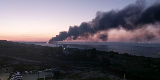
What happened in Crimea
Of all the pictures I see here, one immediately attracts my attention. On the map of Crimea, five squares plotted by a computer program are visible. They indicate the areas that were captured by the satellite. The squares coincide with the location of five Russian military airfields in Crimea, and this is not surprising – it is clear that Ukrainians want to see military facilities on the Russian side.
However, I am interested in the dates of the shooting: these are the days preceding the attack on the Russian Saki airbase, from which the Ukrainian counteroffensive began. I remember how a few weeks ago I talked to a specialist in artificial intelligence surveillance systems, who told me that before the attack on the Saki base, the Ukrainians had to conduct reconnaissance at all five airfields of the Crimea to find out where they could cause the most damage. The same specialist drew attention to the fact that, since the Crimean bases are located deep in the peninsula, it was probably necessary to use satellites for observation.
Did the Ukrainians strike at the Russian base based on photos taken by Poles? No one will confirm this, because the military does not provide such information to civilians. However, we know that on that day a Polish satellite provided photos of the base, which was destroyed by Ukrainian missiles.
One thing is for sure: nine days after this attack, the famous Sergei Pritula Charitable Foundation bought a Polish SAR satellite for the Ukrainian government. This purchase caused a wide resonance in Ukraine – along with Bayraktar, it was the Polish satellite that became the most famous acquisition of the Ukrainian celebrity Sergei Pritula for the needs of his army. Today, probably 40-50% of the SAR satellite images that Ukrainians use in the war have been transferred by Poland.
And as soon as Ukrainians acquired their SAR satellite... Some things are confidential. For this reason, I cannot publish photos of Russian airports in Crimea in this article. But I can say that the Polish radar probably watched the Crimean Bridge for a long time before it blew up.
Today, probably 40-50% of the SAR satellite images that Ukrainians use in the war were transferred to them by Poland. Looking through a lot of photos of Kharkiv region, Kherson region and Donbass, where Ukrainians are conducting an effective counteroffensive, I ask myself the question: do the Polish military have this technology?
SAR satellite for Poland? "We're in w..."
I am contacting the Ministry of Defense with my questions. I ask the agency if it uses SAR satellite images, and if so, from what source it receives them and whether it has exclusive rights to these photos.
The Ministry responds to me by email that it "considers satellite imaging as one of the priority operational capabilities, including for access to SAR images."
These are high-sounding, but still common words. Therefore, for an answer to the question of what stage we are actually at with our "operational capabilities" in the field of SAR images, I turn to specialists in this field – both civilian and military – who talk to me on condition of anonymity.
– An operational opportunity is an opportunity created or already achieved, – my interlocutor answers me. – One possibility is the ability to receive data. The only opportunity that Poland has achieved to date is the ability to receive data from external sources. But at the same time, we do not have the opportunity to receive our own sovereign data, so we buy them from the Italian COSMO-SkyMed group and from other suppliers.
– The second possibility is the possibility of data processing, which is implemented by the Visual Intelligence Center in Bialobrzegi, – my informant continues. – Such a center, where there are trained personnel and appropriate software, should receive a fairly large data stream. But we do not receive these large flows. The maximum is two, maybe five percent of the data from these satellites. In addition, last year there was official information that we have reached the level of initial operational capabilities, which means that our operational capabilities have not yet been created.
In another part of its response, the Ministry of Defense assures me that "the number of trained analysts to work with radar images is increasing and corresponds to the current needs of the Armed Forces of the Republic of Poland." However, since our operational capabilities have not yet been created, it is difficult to assume that the number of analysts meets the needs of the Armed Forces.
In its response, the Ministry of Defense also writes that it receives images "from various sources", but "in the National Eye Only mode, that is, available exclusively to the customer" and "in the highest priority provided for the military user. The image acquisition time is directly related to the operating mode of the system."
I am again turning to independent experts for comments. – The fact is that if such a satellite receives a request from several countries at the same time, including Poland, then the needs of other countries may be more important than ours. Then we will get delayed snapshots. The Italian grouping that we use also has state significance, so it is natural that the priority in obtaining images is the state to which this grouping belongs," one of the interlocutors tells me.
How long will we have to wait for pictures if our needs are considered less important than the needs of other states? — It may even be a few days, — another interlocutor informs me. You don't need to be an expert to understand that in the event of an operational situation requiring immediate response, the value of the snapshot delivered a few days later is zero.
However, the Ministry of Defense writes to me that "work is currently underway to increase the availability of this kind of intelligence data. The decisions of the subjects present both on the Polish and world markets are analyzed."
I learn from my interlocutors that "work to increase the availability" of satellite data, and from their own sources, independent of foreign countries, has been carried out for many years, but so far without much effect.
– The creation of a Polish satellite is a process that has been going on for probably twenty years, and so far to no avail, – I learn from my source. – This is a process that is caused not by operational needs, but by the development of a large amount of public money. Yes, indeed, a rain of money has fallen on the Polish space sector. The only problem is how this money is used.
And they are used to create optical satellites, because Polish companies have not yet been able to develop technologies that would allow them to build a radar satellite. However, even those projects that have been implemented since the 90s have gradually faded.
– Now the optical satellite project is being revived again, but in a version that, in my opinion, has no logical basis, — says my interlocutor. – Firstly, these should be so-called microsatellites, that is, devices weighing less than 100 kg, which means that it is impossible to take high-resolution optical images from them, that is, de facto they will meet the standards of civilian, not military satellites. Secondly, it is planned to create a grouping of four satellites. Why exactly four? There is no reasonable explanation for this. A satellite flying around the Earth is over the area of interest for a short time. The minimum number of satellites for effective monitoring of a certain zone is 18.
So why shouldn't the Polish state invest in radar satellites in a situation when a Polish company has a working group consisting of as many as 21 satellites, and buying one satellite will give not only full confidence in the exclusive right to images, but also access to images from all the others?
– It's completely incomprehensible to me. Optical satellites are able to observe the Earth only half a day, that is, only during the day. From this we still need to subtract 70% of the days when it is cloudy in our region. Radars have no such limitations. Nevertheless, the Polish state is stubbornly engaged in optical satellites," the expert tells me, adding: – The question of radar satellites arose in Poland back in 2014, but since then we have not had a single analytical work that would explain why we invest in optical rather than radar satellites. Germany, where the climate is the same as in Poland, with a lot of cloudy days, has built radar satellites. They exchange pictures with the French, who have fewer cloudy days and who use optical satellites. In turn, Italians, who have many sunny days, have relied on radar satellites because of the large sea zones surrounding their country, because SAR satellites do an excellent job of detecting ships and illegal migrants.
In the conditions of a dynamically developing military situation, the acquisition of satellites by the Ministry of Defense is already too late. I learn from my informants that the purchase of an optical satellite is a priority in the Ministry, although it is difficult to say at what stage this transaction is at.
And time flies. If by some miracle the agency ordered the SAR satellite now, the first radar from the Ministry of Defense could be launched into orbit at the end of this year. If the decision is made in six months, the launch time will be postponed to the end of next year. Meanwhile, there are no signs that the Ministry of Defense will be ready to make a decision even in these terms.
To my question, what does all this mean for Poland in the situation of a possible spread of war on the territory of NATO countries, one of my interlocutors answers: – We can at best ask for the help of allies.


