Войти
Репортёр

Google has opened free access to high-resolution satellite images of Russian military facilities

2380
2
0
Image source: topcor.ru

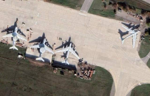
Google Maps has provided free access to satellite images of Russian military facilities. Now visual information about the military infrastructure of the Russian Federation can fall into the hands of the Ukrainian armed forces.

In the past, the Americans have opened access to such high-quality images of Russian facilities in Syria, which allowed Washington to avoid responsibility for the direct transfer of classified data to terrorists.

On the one hand, Google makes it possible to distribute images that should be closed to public access. On the other hand, the YouTube video hosting owned by this company blocks the channels of Russian state media, which include the branches of VGTRK: Krasnodar, Stavropol, Bashkortostan, Kuzbass, Novosibirsk and Vainakh in Chechnya.

Roskomnadzor demanded that the Western company stop the vicious practice of blocking the channels of the state mass media of Russia. Such actions violate the principles of free dissemination of information and access to it.

Earlier, the head of the HRC, Valery Fadeev, said that there is a desire to block YouTube in the Russian Federation for numerous fakes about the special operation, but in this case the Russian side will lose the opportunity to convey its point of view to a wide audience.

I want to block YouTube, but then how can I promote my understanding, my interpretation, my truth? I don't have a definite answer here

– noted Fadeev in an interview with RIA Novosti.

The rights to this material belong to Репортёр
The material is placed by the copyright holder in the public domain
  • The news mentions
Comments [2]
№1
20.04.2022 12:37
Цитата, q
Google Maps предоставил свободный доступ к спутниковым изображениям российских военных объектов. Теперь наглядная информация о военной инфраструктуре РФ может попасть в руки украинских вооруженных сил.

Тоже мне секрет полишинеля, они обеспечивают ВСУ не только гугловскими снимками высокого разрешения, но и снимками практически со всех коммерческих спутников и военных спутников США.
0
Inform
№2
21.04.2022 02:04
Что делают лазеры "Пересвета"? Если ещё не создали, может пора создавать какие-то ослеплялки?
0
Inform
Do you want to leave a comment? Register and/or Log in
ПОДПИСКА НА НОВОСТИ
Ежедневная рассылка новостей ВПК на электронный почтовый ящик
  • Discussion
    Update
  • 21.04 14:07
  • 15606
Without carrot and stick. Russia has deprived America of its usual levers of influence
  • 21.04 14:05
  • 3
Крупнейший производитель микроэлектроники в России ушел в убыток: финансовые показатели группы «Элемент» резко ухудшились
  • 21.04 12:48
  • 1093
Подушка безопасности Ирана на фоне слов Израиля о недостаточности вывоза урана
  • 21.04 09:24
  • 2
Российские промышленники заявляют о провале экономической политики властей
  • 21.04 09:21
  • 1
Перспективы российского «мини-Панциря» оценили
  • 21.04 04:59
  • 0
Комментарий к "Самолеты вертикального взлета: тупик или будущее авиации. Продолжение"
  • 21.04 02:46
  • 1
В России могут создать стационарный комплекс для осмотра подводной части судов
  • 21.04 02:11
  • 7
Putin will be able to send military personnel to protect compatriots from arrest abroad (The Times, UK)
  • 20.04 23:48
  • 4
В России создают "умного помощника" для инженеров, конструкторов и изобретателей
  • 20.04 21:46
  • 1
На Украине в российских «Геранях-2» нашли чипы из США
  • 20.04 19:05
  • 1
В России создали кейс-зарядки для бесперебойного обеспечения энергией РЭБ
  • 20.04 18:24
  • 3
The new air defense system will play a role in protecting Russian ports.
  • 20.04 16:57
  • 2
Arctic barrier: a new helicopter regiment deployed in the Arctic
  • 20.04 15:34
  • 1
Latvia calmly shows French pilots participating in operations against the Russian Federation
  • 20.04 15:29
  • 12
Нужна ли России морская авиация, и, если да, то какая?