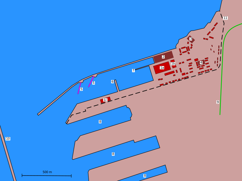
Tartus naval base, from OpenStreetMap; detailed map of the naval base in the port of Tartus.
1a, b, c: Warehouses; 2 dry dock; 3 Parking area for vehicles and equipment (the "Park"); 4 Roll call square; 5 Pontoon bridges that serve as piers; 6 Concrete jetty used as pier; 7 Mooring jetty; 8 Civilian harbour; 9 Railway line; 10 Harbour protection.
Author: Bin im Garten.
Date: June 2011.
1a, b, c: Warehouses; 2 dry dock; 3 Parking area for vehicles and equipment (the "Park"); 4 Roll call square; 5 Pontoon bridges that serve as piers; 6 Concrete jetty used as pier; 7 Mooring jetty; 8 Civilian harbour; 9 Railway line; 10 Harbour protection.
Author: Bin im Garten.
Date: June 2011.
- Источник
- https://en.m.wikipedia.org/
- Размер
- 800 x 600
- Вес
- ~76 kb
- Загружено
- 15.09.2015
- Загрузил
- Peter Tsk
Код для вставки
Код для вставки миниатюры
Код для вставки миниатюры
